
AMERICAN MOTORCYCLIST DECEMBER 2018
Riding The Alcan Highway
A Look Back At A Bucket-List Adventure
By Tom Culbertson
Riding the Alaska-Canadian (Alcan) Highway, which connects the contiguous United States to Alaska across Canada, is a bucket list dream for many bikers.
Completed in 1942 during wartime, the Alcan was a monumental engineering challenge that some have called the biggest and hardest job since the construction of the Panama Canal. The highway was opened to the public in 1948.
Some sixty years later, I made the trip in 2008 with my friend, Monte.
Foolishly, I envisioned the Alcan like any highway—easy riding. It was an incredible treat most of the time, but absolutely scary other times.
Monte and I entered Canada at Osoyoos, B.C., through northern Washington’s semi-arid landscape covered with picturesque vineyards and fruit orchards. Traveling west on Crowsnest Highway, we reached lush forest.
One stop of note is the Hope Slide Memorial. In 1965, Johnson Mountain suffered the largest known landslide in Canadian history, displacing a small lake and covering two miles of Highway 3 and the surrounding valley with 61 million cubic yards of pulverized rock, mud and debris.
Four people died in their vehicles. Within two weeks a temporary roadway was established and eventually engineers rebuilt the highway around the site of the slide.
The next morning, we left Hope, British Columbia, via the Trans-Canada Highway, following the Fraser River into Fraser Canyon, a truly scenic route with curves, tunnels and panoramic river views.
Two interesting sites are Hells Gate and a pair of railroad trestles named Cisco Bridges. Hells Gate is the narrowest point in the Fraser Canyon, at 115 feet. Reportedly, water flow there is greater than Niagara Falls.
Cisco Bridges are an example of corporate competition. Canadian Pacific Railway laid the first tracks through Fraser Canyon on the easier of two difficult routes. Years later, the Canadian National Railway, wanting some business, laid rails on the opposite, more difficult, side. Upon reaching Siska Flat, Canadian National had to cross to the other side. Canadian Pacific simply continued on the easier route.
We pressed on, following the Fraser River to spend the night at Lillooet. In the morning, we rode BC 99 to BC 97 and then north to Prince George.
Here, BC 97 is easy cruising past verdant fields and beautiful stands of trees.
Shortly thereafter we reached Chasm Provincial Park (now Chasm Ecological Reserve), a remnant of melting glaciers creating a notable gorge. At 980 feet deep, 2,000 feet wide and 5 miles long, it is quite an impressive sight.
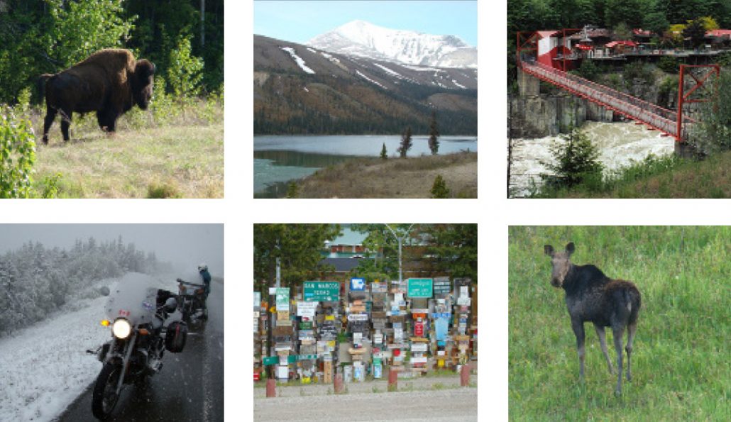
Clockwise from top left: A wood bison that was part of a herd encountered at Watson Lake; Summit Lake, still partially frozen, and Summit Pass, highest pass on the Alcan at 4,250 feet; Hells Gate, the narrowest point on the Fraser River; a moose, just south of Dawson Creek; the Sign Post Forest at Watson Lake; slogging through snow between Whitehorse and Teslin.
Where The Alcan Begins
After spending the night at Prince George, we planned to ride to Dawson Creek, the start of the Alcan Highway.
However, while breakfasting at McLeod Lake, we met a Canadian riding a big Victory. He offered to lead us to Bijoux Water Fall and the scenic Peace River Valley route. We agreed.
Of note, the government wanted a hydroelectric dam to flood the valley, and the route was populated with “Save Peace River Valley” signs. The fight was still ongoing in July 2018.
We spent the night at Fort St John.
Being that far north, we had considerable morning light that allowed early departures. Forging ahead on the Alcan, our next layover was Fort Nelson. Riding was easy. Occasionally, there were speeders rushing by us. But most the time, we were alone amid a forest of skinny, short conifer trees.
Riding from Fort Nelson, the Alcan becomes more challenging, though not difficult, and still enjoyable. Swaying through the curves was a welcome change. Reaching Stone Mountain Provincial Park, we were presented with incredible scenery and more intense curves.
Shortly afterwards we passed Summit Lake—which was still partially frozen—and reached Summit Pass, the highest pass on the Alcan at 4, 250 feet.
If you make this trip, watch for the Stone sheep—they don’t respect vehicles!
Traveling onward, we stopped for breakfast at the Toad River Inn. Of course, I left a cap for their lost-and-found collection.
Our next stop was Watson Lake, Yukon Territory. The Sign Post Forest is a notable site here. Travelers from around the world have been bringing signposts from their hometowns to the Sign Post Forest since 1942.
Departing early the next morning, we were making good progress when we saw a smoky cloud on the horizon. Worrying about fire, we rode onward. Foolish us, it was just road construction. After a long wait, the flagger came with an offer to move us ahead. Knowing we would ride the gravel slowly, we chose to go last.
Past the road work, we received a surprise: A bear was foraging beside the road.
More Challenges Await
The Teslin Bridge loomed before us. It is a steel structure with an expanded metal road surface. Motorcycles wander all over on this stuff. Spooky!
Surviving road work and the bridge, we cruised closer to Alaska. After a night at Haines Junction, Yukon Territory, there was one more day of riding before reaching Tok, Alaska.
However, the Alcan wasn’t through with us. Thirty miles into Alaska, we hit major construction. The road was gone and they were spreading three-quarter-inch crushed gravel for 15 miles. This stretch was the biggest challenge so far.
Arriving at Tok, our final destination, we had time to relax, do laundry and explore.
The next morning, we departed Tok early to avoid traffic on the 15-mile construction zone. The gravel was firmly compacted, allowing easy passage.
Reaching Destruction Bay, Yukon Territory, most of the construction was behind us and we could enjoy the grand scenery: snowy mountains, blue lakes, green, stunted conifer forests and many miles of blooming fireweed wildflowers, the Yukon Territory’s official flower.
I was still looking for a moose. Maybe my only one would be on the sign warning us about them.
We slogged through snow between Whitehorse and Teslin. Luckily, the roadway was warm enough to melt the snow while it built up on trees along the roadside. When we reached Teslin, my hands were so cold that Monte had to unbuckle my helmet for me.
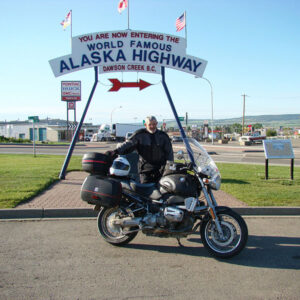
The marker at Dawson Creek identifying the beginning of the Alcan Highway.
After a hearty breakfast, we motored over squirmy Teslin bridge and continued south.
Arriving at Watson Lake for the night, we encountered a herd of wood bison. These creatures are bigger and heavier than our plains bison, with large males weighing over 2,000 lbs.
On our return trip, we decided to go to Dawson Creek, the start of Alcan Highway. Amazingly, south of Dawson Creek, there was a young moose along the roadside in some grassy woods!
We followed BC 97 south through the middle of British Columbia to Osoyoos and the border crossing. This last leg was quite sedate compared to our days on the Alcan.
It’s been 10 years, and I still have many fond memories of the Alcan. The road is at once fulfilling, challenging, exciting and scary. If you are planning to go, here are two tips: Lodging fills up quickly, so make your reservations six months ahead. Remember, summer is road “repair” time. Crews demolish entire sections of roadway and start from scratch, so be prepared for some “off-road” adventure.
Tom Culbertson is an AMA member from Port Hueneme, Calif.